Synergetics Coordinates

Synergetics Coordinates
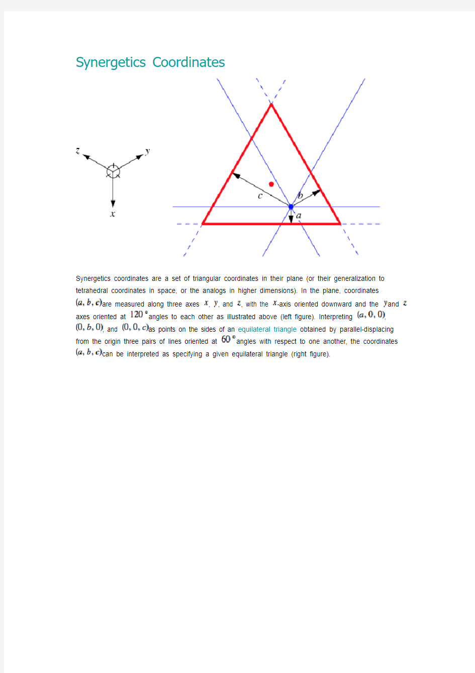
Synergetics coordinates are a set of triangular coordinates in their plane (or their generalization to tetrahedral coordinates in space, or the analogs in higher dimensions). In the plane, coordinates are measured along three axes , , and , with the -axis oriented downward and the and axes oriented at angles to each other as illustrated above (left figure). Interpreting , , and as points on the sides of an equilateral triangle obtained by parallel-displacing from the origin three pairs of lines oriented at angles with respect to one another, the coordinates can be interpreted as specifying a given equilateral triangle (right figure).
A nice property of these coordinates is that the vertices of the triangle obtained by parallel-displacing by
are given by , , and (see above figure), so that the sums of the coordinates of the vertices are always zero. This property also holds when the coordinates are generalized to three and higher dimensions.
The synergetics coordinates also have the property that the edge lengths of the equilateral triangle described by is precisely , which again generalizes to higher dimensions.
Synergetics coordinate provide a convenient way to construct regular circle and sphere packings. For example, the ring of circles illustrated above at left can be generated by picking all sets of integer synergetics coordinates that sum to zero and such that the sum of the absolute values of the three coordinates divided by two equals one (Nelson). Similarly, the second ring of circles can be obtained from all sets of integer coordinates that sum to zero and such that the sum of the absolute
values of the three coordinates divided by two equals one. The zeroth, first, and second rings are illustrated above at right.
Similar properties hold in three dimensions, where appropriate sets of synergetics coordinates give successive shells in a regular sphere packing (Nelson), illustrated above.
流体力学中英文术语
Index 翻译(Fluid Mechanics) Absolute pressure,绝对压力(压强)Absolute temperature scales, 绝对温标Absolute viscosity, 绝对粘度Acceleration加速度centripetal, 向心的convective, 对流的Coriolis, 科氏的 field of a fluid, 流场 force and,作用力与……local, 局部的 Uniform linear, 均一线性的Acceleration field加速度场Ackeret theory, 阿克莱特定理Active flow control, 主动流动控制Actuator disk, 促动盘 Added mass, 附加质量Adiabatic flow绝热流 with friction,考虑摩擦的isentropic,等熵的 air, 气体 with area changes, 伴有空间转换Bemoullii’s equation and, 伯努利方程Mach number relations,马赫数关系式,pressure and density relations, 压力-速度关系式sonic point,critical values, 音速点,临界值,stagnation enthalpy, 滞止焓Adiabatic processes, 绝热过程Adiabatic relations, 绝热关系 Adverse pressure gradient, 逆压力梯度 Aerodynamic forces, on road vehicles, 交通工具,空气动力 Aerodynamics, 空气动力学 Aeronautics, new trends in, 航空学,新趋势 Air空气 testing/modeling in, 对……实验/建模 useful numbers for, 关于……的有用数字 Airbus Industrie, 空中客车产业 Aircraft航行器 airfoils机翼 new designs, 新型设计 Airfoils, 翼型 aspect ratio (AR), 展弦比 cambered, 弧形的 drag coefficient of , 阻力系数 early, 早期的 Kline-Fogleman, 克莱恩-佛莱曼 lift coefficient, 升力系数 NACA, (美国) 国家航空咨询委员会separation bubble, 分离泡 stalls and, 失速 stall speed, 失速速度 starting vortex, 起动涡 stopping vortex, 终止涡 Airfoil theory, 翼型理论 flat-plate vortex sheet theory, 平板面涡理论 Kutta condition, 库塔条件 Kutta-Joukowski theorem, 库塔-儒科夫斯基定理 1
简介笛卡尔坐标系
简介笛卡尔坐标系 (Cartesian coordinates)(法语:les coordonnées cartésiennes )就是直角坐标系和斜角坐标系的统称。相交于原点的两条数轴,构成了平面放射坐标系。如两条数轴上的度量单位相等,则称此放射坐标系为笛卡尔坐标系。两条数轴互相垂直的笛卡尔坐标系,称为笛卡尔直角坐标系,否则称为笛卡尔斜角坐标系。 推广放射坐标系和笛卡尔坐标系平面向空间的推广。相交于原点的三条不共面的数轴构成空间的放射坐标系。三条数轴上度量单位相等的放射坐标系被称为空间笛卡尔坐标系。三条数轴互相垂直的笛卡尔坐标系被称为空间笛卡尔直角坐标系,否则被称为空间笛卡尔斜角坐标系。笛卡尔坐标,它表示了点在空间中的位置,但却和直角坐标有区别,两种坐标可以相互转换。举个例子:某个点的笛卡尔坐标是493 ,454, 967,那它的X轴坐标就是4+9+3=16,Y轴坐标是4+5+4=13,Z轴坐标是9+6+7=22,因此这个点的直角坐标是(16, 13, 22),坐标值不可能为负数(因为三个自然数相加无法成为负数)。 笛卡尔和笛卡尔坐标系的产生据说有一天,法国哲学家、数学家笛卡尔生病卧床,病情很重,尽管如此他还反复思考一个问题:几何图形是直观的,而代数方程是比较抽象的,能不能把几何图形与代数方程结合起来,也就是说能不能用几何图形来表示方程呢?要想达到此目的,关键是如何把组成几何图形的点和满足方程的每一组“数”挂上钩,他苦苦思索,拼命琢磨,通过什么样的方法,才能把“点”和“数”联系起来。突然,他看见屋顶角上的一只蜘蛛,拉着丝垂了下来,一会功夫,蜘蛛又顺着丝爬上去,在上边左右拉丝。蜘蛛的“表演”使笛卡尔的思路豁然开朗。他想,可以把蜘蛛看做一个点,它在屋子里可以上、下、左、右运动,能不能把蜘蛛的每个位置用一组数确定下来呢?他又想,屋子里相邻的两面墙与地面交出了三条线,如果把地面上的墙角作为起点,把交出来的三条线作为三根数轴,那么空间中任意一点的位置就可以用这三根数轴上找到有顺序的三个数。反过来,任意给一组三个有顺序的数也可以在空间中找出一点P与之对应,同样道理,用一组数(x、y)可以表
色度色座标
1. 輻射束(joule/sec) 2. 光束/光通量(lumen) 3. 光度(Candela, cd) 4. 輝度(cd/m 2) 5. 照度(Lux) 6. 光束發散度(radlux) 7. 反射率(reflectivity) 8. 電光源效率(power eff.) 七、色度與CIE 色度座標色度座標之測定之測定之測定--發光學術語與基本概念
發光光度學常用單位與定義 電磁波於單位時間內所傳播的輻射能量(J/sec)或Watt F = KΦ (K為視覺度,其大小依波長而異,其最大值為100, F為光束 2.光束/光通量(luminous, 單位:流明Lumen) 光源所發出的總光量或單位時間內所通過的光量, 可用照度計加以量測
3.光度I (Luminous intensity,單位為燭光Cd, candela)一光源在冇一方向所發出光的強度稱之為光度,假設dω為一微小立體角,其包含的光束為dF,則此光源箭頭方向的光度(I)為 I = 光束/立體角= dF/dω所以dF= I dω 此立體角內所有方向之光度I 則為I =dF/dω 對均勻的點光源而言,,F (lumen) = 4πI (單位為燭光) 對均勻的點光源而言 其中4π為總立體角
各種光源的輝度值(nit) 太陽165 x 107 月亮26 x 102蠟燭1 x 10⁴ 藍空8 x 10³水銀燈14 x 104 日光燈6x 10³-1x 10⁴ 納氣燈(200W) 8 x1044. 輝度L (Brightness, 單位為nit 或nt = cd/m 2或stilb (sb), sb = cd/m 2由一特定的光源發出強度相同時由一特定的光源發出強度相同時,,其發光的面積越大者其發光的面積越大者,,則其輝度值 越小越小。。 某一截面的輝度L (nit)值,為其該方向的光度值I (cd),以該截面的 視面積A (m 2)除得之值除得之值,,以L 表示 L = I (cd)/A (m 2) = nit or cd/m 2or stilb
管道工程常用英语
stake No. 桩号elevation标高coordinates坐标mileage(chainage)里程obstacle/ barrier障碍物instrument 仪器alignment sheet 线路图/定线图benchmark 基准点restricted 受限制的 ROW/ right-of-way 作业带Clear/clean the ROW 清理作业带 land scraper (grader) 平地机excavator 挖掘机dozer 推土机width 宽度pipe yard 堆管场camp 营地crane 吊车load 装车offload 卸车 side boom 吊管机low-bed trailer 低板车move forward往前移 know well of 对…熟悉pipe hauling 运管destination目的地 preheat 加热be in charge of 负责tie-in 连头pipe jacking 顶管quality control/QC 质量控制root face钝边manual welding 手工焊 lower-in 下沟backfill 回填complete完成bedding material 垫层材料spread 摊铺compact 压实interval间隔partial backfilling 小回填 conform to 符合,遵照cubic meter立方米carry out 执行 hydro testing试压section管段tightness 严密性strength强度 flow rate流速filling pig注水球dewater 排水density密度 foam pig泡沫球swab扫水dryer干燥机epoxy resin 环氧树脂 inspect检验coincident with 与……一致solidify凝结,冻结 holiday detector 电火花检漏仪embed 埋设temporary 临时的calibration 校验permanent 永久的verify 核实test pole 测试桩tape ruler 卷尺parallel to 与……平行 radically 根本上furthermore 此外respectively分别地diagram 简图veragely平均地clay泥土,粘土rotate旋转failure 失败,失误exceed 超过guarantee 保证jacking work 顶管施工duty-on-shift 轮流值班round o’clock 24小时fatigue 疲劳hose 软管refuel 加油grouting 灌浆bentonite 膨润土,泥浆ream 扩孔bore pipe 钻杆bore bit 钻头pilot hole 导孔slurry 泥浆friction 摩擦stability 稳定性facility设施satisfactory 满意sufficient充足的strictly 严格地 risk assessment 风险评估frac-out 漏浆dispose 处理fluid 液体,泥浆
调整abaqus中节点坐标的方法
Abaqus Analysis User's Manual 2.1.6 Adjusting nodal coordinates Products: Abaqus/Standard Abaqus/Explicit Abaqus/CAE References ? *ADJUST ? “Defining adjust points constraints,” Section 15.15.5 of the Abaqus/CAE User's Manual Overview Nodal adjustment is used for: ? adjusting user-specified nodal coordinates so that the nodes lie on a given surface; and ? specifying the direction along which the nodes are moved. Adjusting nodal coordinates In general, user-specified nodal coordinates are not modified during input file processing. However, there are some situations where mesh coordinates are known only in a generic way and it is inconvenient to determine their coordinates for their actual usage. For example, when using fasteners the specified reference node should be positioned at its projection point on the associated surface. Since that location may be known only approximately, you can use nodal adjustment to move the reference node to that location automatically. For typical usage of the nodal adjustment feature, refer to “About assembled fasteners,” Section 29.1.3 of the Abaqus/CAE User's Manual . When using this feature, the nodes are adjusted to lie on the specified surface without regard for shell thickness or shell offsets. Therefore,
坐标转换
用TranslateCoordinates方法可以将一个点或一段位移由一个坐标系统转换到另一个坐标系统。一个点变量,称为OriginalPoint,可以被视为一个三维点或一个三维位移矢量。这个变量由Boolean变量- Disp 来区分。如果Disp变量被设为TRUE的话,OriginalPoint变量就被视为一个位移矢量;反之,则被视为一个点。两个以上的变量可以决定这个OriginalPoint来自哪个坐标系统,也可以决定这个OriginalPoint要被转换到哪个坐标系统。以下的AutoCAD坐标系统可以被指定为From和To变量。 WCS 世界坐标系统即参照坐标系统。其它所有的坐标系统都是相对WCS 定义的,WCS是永远不改变的。相对于WCS测量的值可以忽略其它坐标系统的变化。除了特殊说明,所有传进或传出ActiveX方法和属性的点都用WCS表示。 UCS 用户坐标系统即工作中的坐标系统。用户指定一个UCS以便绘图更容易。所有传到AutoCAD命令的点,包括那些从AutoLISP程序和外部功能返回的,都是当前UCS的点(除了在命令提示符后用户在前面加了个*的点)。如果你想用程序将WCS、OCS或DCS坐标传到AutoCAD命令,你必须首先通过调用TranslateCoordinates方法将它们转换成UCS。
OCS 对象坐标系统-由多义线和细多义线对象的某些方法和属性指定的点的值由这种坐标系统表达,与对象有关。这些点通常根据对象的用途被转换成WCS、当前的UCS或当前的DCS。相反的,在WCS、UCS 或DCS中的点依靠相同的属性写进数据库之前,必须被转换成OCS。要了解使用该坐标系统的方法和属性,请参看AutoCAD中的"ActiveX 和VBA 参考"。 当从OCS转换坐标或转换坐标到OCS时,你必须输入TranslateCoordinates方法中的最后一个参数OCS法线。 DCS 显示坐标系统即对象在显示前被转换的坐标系统。DCS的原点是被存在AutoCAD系统变量TARGET中的点,它的Z轴就是视图方向。换句话说,一个视口始终是它的DCS平面图。这些坐标可用于决定物体是从哪里显示给AutoCAD用户的。 PSDCS 图纸空间DCS-该坐标系统只能从当前活动的模型空间视口的DCS转入或转出。这本来是一个二维的转换,如果Disp变量为FALSE,X 和Y坐标总是按比例来偏移的。Z坐标也是按比例的但是从不转换。因此,可以用Z坐标来找到两个坐标系统之间的比例因子。PSDCS
流体力学C-名词解释
Chapter 1 Fluid statics 流体静力学 1. 连续介质假定(Continuum assumption):The real fluid is considered as no-gap continuous media, called the basic assumption of continuity of fluid, or the continuum hypothesis of fluid.流体是由连续分布的流体质点(fluid particle)所组成,彼此间无间隙。它是流体力学中最基本的假定,1755年由欧拉提出。在连续性假设之下,表征流体状态的宏观物理量在空间和时间上都是连续分布的,都可以作为空间和时间的函数。 2. 流体质点(Fluid particle ): A fluid elementthat is small enough with enoughmoles to make sure that the macroscopic meandensity has definite valueis defined as a Fluid Particle.宏观上足够小,微观上足够大。 3. 流体的粘性(Viscosity ): is an internal property of a fluid that offers resistance to shear deformation. It describes a fluid's internal resistance to flow and may be thought as a measure of fluid friction.流体在运动状态下抵抗剪切变形的性质,称为黏性或粘滞性。它表示流体的内部流动阻力,也可当做一个流体摩擦力量。The viscosity of a gas increases with temperature, the viscosity of a liquid decreases with temperature. 4. 牛顿内摩擦定律(Newton’s law of viscosity ): 5. The dynamic viscosity (动力黏度)is also called absolute viscosity (绝对黏度). The kinematic viscosity (运动黏度)is the ratio of dynamic viscosity to density. 6. Compressibility (压缩性):As the temperature is constant, the magnitude of compressibility is expressed by coefficient of volume compressibility (体积压缩系数) к , a relative variation rate (相对变化率) of volume per unit pressure. The bulk modulus of elasticity (体积弹性模量) E is the reciprocal of coefficient of volume compressibility к. 7. 流体的膨胀性(expansibility; dilatability):The coefficient of cubical expansion (体积热膨胀 系数) αt is the relative variation rate of volume per unit temperature change. 8. 表面张力Surfacetension : A property resulting from the attractive forces between molecules.σ-----单位长度所受拉力 9. 表面力 Surface force ——is the force exerted on the contact surface by the contacted fluid or other body. Its value is proportional to contact area.作用在所研究流体外表面上与表 du dz τμ=μ νρ =
Laplace equation in spherical coordinates 球坐标下的拉普拉斯方程
LAPLACE’S EQUATION IN SPHERICAL COORDINATES With Applications to Electrodynamics We have seen that Laplace’s equation is one of the most significant equations in physics. It is the solution to problems in a wide variety of fields including thermodynamics and electrodynamics. In your careers as physics students and scientists, you will encounter this equation in a variety of contexts. It is important to know how to solve Laplace’s equation in various coordinate systems. The coordinate systems you will encounter most frequently are Cartesian, cylindrical and spherical polar. We investigated Laplace’s equation in Cartesian coordinates in class and just began investigating its solution in spherical coordinates. Let’s expand that discussion here. We begin with Laplace’s equation: 02=?V (1) We can write the Laplacian in spherical coordinates as: )(sin 1)(sin sin 1)(122222222φ θθθθθ??+????+????=?V r V r r V r r r V (2) where θ is the polar angle measured down from the north pole, and φ is the azimuthal angle, analogous to longitude in earth measuring coordinates. (In terms of earth measuring coordinates, the polar angle is 90 minus the latitude, often termed the co- latitude .) To make our initial calculations a little simpler, let’s assume azimuthal symmetry ; that means that our parameter V does not vary in the φ direction. In other words, 0/=??φV , so we can write the Laplacian in (2) a bit more simply. Assuming azimuthal symmetry, eq. (2) becomes: )(sin sin 1)(12222θθθ θ????+????=?V r r V r r r V (3) This is the form of Laplace’s equation we have to solve if we want to find the electric potential in spherical coordinates. First, let’s apply the method of separable variables to this equation to obtain a general solution of Laplace’s equation, and then we will use our general solution to solve a few different problems. To solve Laplace’s equation in spherical coordinates, we write:
数学术语
V、X、Z: Value of function :函数值 Variable :变数 Vector :向量 Velocity :速度 Vertical asymptote :垂直渐近线 V olume :体积 X-axis :x轴 x-coordinate :x坐标 x-intercept :x截距 Zero vector :函数的零点 Zeros of a polynomial :多项式的零点 T: Tangent function :正切函数 Tangent line :切线 Tangent plane :切平面 Tangent vector :切向量 Total differential :全微分 Trigonometric function :三角函数Trigonometric integrals :三角积分Trigonometric substitutions :三角代换法 Tripe integrals :三重积分 S: Saddle point :鞍点 Scalar :纯量 Secant line :割线 Second derivative :二阶导数 Second Derivative Test :二阶导数试验法Second partial derivative :二阶偏导数 Sector :扇形 Sequence :数列 Series :级数 Set :集合 Shell method :剥壳法 Sine function :正弦函数 Singularity :奇点 Slant asymptote :斜渐近线 Slope :斜率 Slope-intercept equation of a line :直线的斜截式
Slippy map tilenames(瓦片和经纬度换算)
Slippy map tilenames(瓦片和经纬度换算) This article describes the file naming conventions for the Slippy Map application.Tiles are 256 × 256 pixel PNG filesEach zoom level is a directory, each column is a subdirectory, and each tile in that column is a fileFilename(url) format is /zoom/x/y.pngThe slippy map expects tiles to be served up at URLs following this scheme, so all tile server URLs look pretty similar.目录[隐藏] 1 Tile servers2 Zoom levels3 X and Y4 Derivation of tile names5 Implementations5.1 Pseudo-code5.1.1 Lon./lat. to tile numbers5.1.2 Tile numbers to lon./lat.5.2 Mathematics5.3 Python5.3.1 Lon./lat. to tile numbers5.3.2 Tile numbers to lon./lat.5.4 Ruby5.4.1 Lon./lat. to tile numbers5.4.2 Tile numbers to lon./lat.5.5 Perl5.5.1 Lon./lat. to tile numbers5.5.2 Tile numbers to lon./lat.5.5.3 Lon./lat. to bbox5.6 PHP5.6.1 Lon./lat. to tile numbers5.6.2 Tile numbers to lon./lat.5.7 ECMAScript (JavaScript/ActionScript, etc.)5.8 C/C++5.9 Go5.10 Java5.10.1 Tile bounding box5.11 https://www.wendangku.net/doc/1f2949848.html,5.12 C#5.13 XSLT5.14 Haskell5.15 Scala5.16 Revolution/Transcript5.17 Mathematica5.18 Tcl5.18.1 Lat./lon. to tile number5.18.2 Tile number to lat/lon5.19 Pascal5.19.1 Coordinates to tile numbers5.19.2 Tile numbers to
微积分中的关键术语
微积分中的关键术语 常量:习惯用字母a,b,c,d等表示; 变量:习惯用字母x,y,z,u,v,w等表示. 函数关系:变量与变量之间的对应关系; 极限:变量的变化趋势; 导数:变量变化的快慢程度(变化率问题); 微分:函数在某一点处,当自变量有一个微小的改变量时,函数所取得的相应改变量的大小。dy ?; y≈ 积分学:已知某个函数F(x)的导函数f(x),求F(x),使()()x ' F= x f Value of function :函数值 Variable :变数 Vector :向量 Velocity :速度 Vertical asymptote :垂直渐近线 V olume :体积 X-axis :x轴 x-coordinate :x坐标 x-intercept :x截距 Zero vector :函数的零点 Zeros of a polynomial :多项式的零点 T: Tangent function :正切函数
Tangent line :切线 Tangent plane :切平面 Tangent vector :切向量 Total differential :全微分Trigonometric function :三角函数Trigonometric integrals :三角积分Trigonometric substitutions :三角代换法Tripe integrals :三重积分 S: Saddle point :鞍点 Scalar :纯量 Secant line :割线 Second derivative :二阶导数 Second Derivative Test :二阶导数试验法Second partial derivative :二阶偏导数Sector :扇形 Sequence :数列 Series :级数 Set :集合 Shell method :剥壳法 Sine function :正弦函数 Singularity :奇点 Slant asymptote :斜渐近线 Slope :斜率
匈牙利表示法
匈牙利表示法 匈牙利命名法是微软推广的一种关于变量、函数、对象、前缀、宏定义等各种类型的符号的命名规范。匈牙利命名法的主要思想是:在变量和函数名中加入前缀以增进人们对程序的理解。它是由微软内部的一个匈牙利人Charles Simonyi(他后来成为微软的著名程序员)发起使用的。微软后来采用了这个思想,给每个标识符一个前缀以说明它的数据类型。结果它在微软内部逐渐流行起来,并且推广给了全世界的Windows开发人员。下面将介绍匈牙利命名法。 a Array 数组 b BOOL (int) 布尔(整数) by Unsigned Char (Byte) 无符号字符(字节) c Char 字符(字节) cb Count of bytes 字节数 cr Color reference value 颜色(参考)值 cx Count of x (Short) x的集合(短整数) dw DWORD (unsigned long) 双字(无符号长整数) f Flags (usually multiple bit values) 标志(一般是有多位的数值) fn Function 函数 g_ global 全局的 h Handle 句柄 i Integer 整数
l Long 长整数 lp Long pointer 长指针 m_ Data member of a class 一个类的数据成员 n Short int 短整数 p Pointer 指针 s String 字符串 sz Zero terminated String 以0结尾的字符串 tm Text metric 文本规则 u Unsigned int 无符号整数 ul Unsigned long (ULONG) 无符号长整数 w WORD (unsigned short) 无符号短整数 x,y x, y coordinates (short) 坐标值/短整数 v void 空 有关项目的全局变量用g_开始,类成员变量用m_,局部变量若函数较大则可考虑用l_用以显示说明其是局部变量。
Coordinate measuring machines翻译
Coordinate measuring machines, commonly referred to as CMM, are flexible dimensional measuring devices. See Fig. R9-1.CMM is widely used for the post- process inspection of machines, molded and fabricated components. CMM operates with the aid of three perpendicular axis measuring scales and a special contact-sensitive probe to detect the surface of the component. 坐标测量机,通常被称为CMM,是灵活的尺寸测量装置。见图。r9 1。CMM是广泛用于post -流程检查机,模制和捏造的组件。CMM进行援助的三个垂直轴测量尺度和一个特殊的 接触敏感探针来检测组件的表面。 When a component is to be inspected, it is positioned on the CMM table, and the contacting stylus of the probe is moved to touch the appropriate feature of the part. This is completed by moving the axis slides to which are attached the measuring scales. The scales are read at the point of probe
测绘工程专业英语课文翻译Unit-14Datums, Coordinates and Conversions
Unit14 Datums, Coordinates and Conversions (已知坐标转换) A datum is the mathematical model of the Earth we use to calculate the coordinates and elevations on any map , chart, or survey system . Geodetic datum s define the size and shape of the Earth and the origin and orientation of the coordinate systems used to map the Earth . Hundreds of different datum s have been used to frame position descriptions since the first estimates of the Earth’s size were made by Aristotle . But all coordinates reference some particular set of numbers for the size and shape of the Earth . For example, the Global Positioning System (GPS) is based on the World Geodetic System 1984 (WGS-84) . Many countries use their own datums when they make their maps and surveys—what we call local datums .(基准是我们用来计算任何地图、海图或测量系统的坐标和海拔的地球的数学模型。大地测量数据定义了地球的大小和形状,以及用于映射地球的坐标系的起源和方向。数以百计的不同的数据已被用于帧位置描述,因为第一次估计地球的大小是由亚里士多德。但是所有坐标都引用了地球的大小和形状的一些特定的数字集。例如,全球定位系统(GPS)是基于世界大地测量系统1984(WGS-84)。许多国家使用自己的数据时,他们使他们的地图和调查,我们称之为局部基准。) Horizontal and Vertical Datums(水平和垂直数据) In geodesy two types of datums must be considered: a“Horizontal Datum ”for location ,which for m s the basis for the computations of horizontal control surveys in which the curvature of the Earth is considered and a“Vertical Datum ”for elevation or to which elevations are referred . Vertical control networks provide elevations with reference to a surface of constant gravity force called the geoid . Almost all maps and charts use mean sea level (geoid) for elevation . But they might use any of over hundred different horizontal position datums . One example of horizontal datum is a mathematical surface called a reference ellipsoid with which positional information (latitude and longitude) is referenced to . T he coordinates for points in specific geodetic surveys and triangulation networks are computed from certain initial quantities (datums) . Sometimes, a map will have more than one grid on it .Normally,each grid is for a different datum .(在大地测量中的两种基准必须考虑:“水平面”位置,为M S为基础,计算平面控制测量中,被认为是地球的曲率和“垂直基准”,海拔高程或被称。垂直控制网络提供海拔参考的表面重力称为大地水准面的恒定重力。几乎所有的地图和海图都使用平均海平面(大地水准面)进行高程测量。但他们可能使用任何超过百种不同的水平位置的基准。一个例子的水平基准是一个数学表面称为参考椭球与位置信息(纬度和经度)是参照。他在
- Coordinate measuring machines翻译
- 色度色座标
- 多维数据可视化
- 超音速翼型在fluent中的流场分析
- 微积分中的关键术语
- Coordinate System
- 栅格数据坐标变换
- 2.Coordinate Systems
- About coordinates of CAD(in Chinese)
- Abaqus计算报错总结
- 坐标转换
- Laplace equation in spherical coordinates 球坐标下的拉普拉斯方程
- Slippy map tilenames(瓦片和经纬度换算)
- 测绘工程专业英语课文翻译Unit-14Datums, Coordinates and Conversions
- 最新Texture Coordinates
- 色度学基础知识介绍
- 数学术语
- 匈牙利表示法
- 简介笛卡尔坐标系
- AE CS3 Polar Coordinates特效和Bezier Warp特效